Wishlist
Search
  • Home
  • Shop
    • London Maps
    • Continents & World
    • Country Maps
    • City Maps
    • UK Cities & Counties
    • Antique Illustrations
  • Inspirations
  • Blog
  • About Us
  • Contact us
Login / Register
0 items £0.00
Menu
0 items £0.00
Click to enlarge
Home UK Cities & Counties SHROPSHIRE 1760
JAPAN 1864 £27.00 – £45.00
Back to products
WARWICKSHIRE 1787 £27.00

SHROPSHIRE 1760

£27.00

Clear
Buy with

– OR –

Add to wishlist
15 People watching this product now!
SKU: N/A Category: UK Cities & Counties Tags: &, 1760, cities, counties, handmade, linen backed, shropshire, uk
Share:
Close
YOU MAY ALSO LIKE…
  • BRITISH EMPIRE 1872 £27.00 – £45.00
  • HOLLAND 1851 £27.00 – £45.00
  • MUSHROOMS (Champignons) Circa 1897 £23.00
  • BATH 1851 £27.00
  • ABERDEEN 1851 £27.00
  • THE SHIRE OF DUMFRIES OR NITHISDALE 1725 £27.00
  • Description
  • Additional information
  • Reviews (0)
  • Shipping & Delivery
  • Product Information
Description

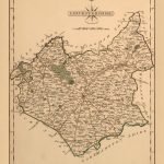
An accurate map of Shropshire divided into its hundreds. Drawn and compiled from the most approved maps&surveys &illustrated with various additional improvements. Also, historical exctracts realtive to trade, manucatutres, natural history & not extant in any other map of this county.


YEAR:1760


CARTOGRAPHER: Emanuel Bowen

Additional information
Weight N/A
Size

51×39 cm

Reviews (0)
Rated 0 out of 5
0 reviews
Rated 5 out of 5
0
Rated 4 out of 5
0
Rated 3 out of 5
0
Rated 2 out of 5
0
Rated 1 out of 5
0

Reviews

Clear filters

There are no reviews yet.

Be the first to review “SHROPSHIRE 1760” Cancel reply

You must be logged in to post a review.

Shipping & Delivery

All Orders are processed within by next day - Monday through Friday (excluding holidays). Orders are not shipped or delivered on weekends or holidays.

If We are experiencing a high volume of orders, shipments may be delayed by a few days. Please allow additional days in transit for delivery. If there will be a significant delay in shipment of Your Order, We will contact You via email.

Shipping rates & delivery estimates

Shipping charges for Your Orders will be calculated and displayed at checkout.

UK Delivery:

●  Shipping method: Royal Mail 2nd Class Standard

●  Shipment cost: Free

Estimated delivery time: 3-5 business days


Worldwide Delivery:

●  Shipping method: Royal Mail International Tracked & Signed

●  Shipping cost: Calculated at checkout according to weight, size and Zones. (View Table)

●  Estimated delivery time: 8-14 business days

Delivery delays can occasionally occur.

Europe

Zone 1

Zone 2

Zone 3

Small Map Size

£9.90

£11.20

£12.25

£11.35

Large Map Size

£14.20

£20.35

£22.10

£23.75

Illustrations (tube)

£12.65

£16.45

£17.60

£18.35

World Zone 1: Covers all countries, not defined as being in Europe or World Zone 2. (World Zone 1 generally covers countries in North America, South America, the Middle East, the Far East and South East Asia).

World Zone 2: Australia, Belau(Palau), China (including Tibet), East Timor, Fiji, French Southern and Antarctic Territories, French Polynesia, Guam, Japan, Kiribati, Korea, Marshall Islands, Micronesia, Mongolia, Nauru Islands, New Caledonia, New Zealand, Norfolk Island, North Marina Island, Papua New Guinea, Philippines, Pitcairn Island, Samoa, Solomon Islands, Singapore, Taiwan, Tonga, Tuvalu, Vanuatu, Wake Island, Wallis and Futuna Islands, Western Samoa.

World Zone 3: USA


* Prices may vary according to size and weight. Final shipping fees are calculated at checkout.

Product Information

Our unique product have been meticulously crafted, with great care and attention to detail.

✶ All Maps and illustrations are linen-backed by hand.
✶ Printed on Archival Matte Paper.
✶ Quality Epson pigment inks used. Fade resistant.
✶ Maps are folded and fitted into a hand wrapped marbled slipcase.
✶ Illustrations are rolled and posted in a sturdy cardboard tube.
✶ Dimensions are approximately. Select size from the menu.
✶ Colours may vary due to monitor resolution.

Linen backing provided several benefits to cartographers and map enthusiasts:

✶ Preservation: The technique helps protect paper maps from further deterioration by providing a stronger and more stable support.
✶ Sturdiness: Linen backing make maps more durable, preventing tearing and creasing during handling and storage.
✶ Display: Backed maps are easier to frame and display due to their enhanced stability and ability to lie flat.

Related products

Select options
Quick view
Add to wishlist
100x55 cm
133x76 cm
55x31 cm

WORLD MAP 1799

Continents & World
£27.00 – £90.00
Select options
Quick view
Add to wishlist
33x51 cm

MUSHROOMS (Champignons) Circa 1897

Antique Illustrations
£23.00
Select options
Quick view
Add to wishlist
52x40 cm
79x60 cm

ARABIA 1851

Continents & World
£27.00 – £45.00
Select options
Quick view
Add to wishlist
124x90 cm
51x37 cm
84x60 cm

THE STRANGER’S GUIDE THROUGH THE STREETS OF LONDON AND WESTMINSTER, YEAR 1814

London Maps
£27.00 – £90.00
Select options
Quick view
Add to wishlist

AFRICA 1851

Continents & World
£27.00 – £45.00
Select options
Quick view
Add to wishlist
60x61 cm
90x90 cm

TWENTY MILES ROUND LONDON 1800

London Maps
£45.00 – £90.00
Select options
Quick view
Add to wishlist
51x38 cm

MIDDLE EAST 1866

Continents & World
£27.00
Select options
Quick view
Add to wishlist
102x78 cm
80x60 cm

TALLIS’S ILLUSTRATED PLAN OF LONDON AND ITS ENVIRONS 1851

London Maps
£45.00 – £90.00
You must select your brand attribute in Theme Settings -> Shop -> Brands
  • +44 753 4988 166
  • info@oldmapslibrary.com
Recent Posts
  • Woman in Cartography
    22/03/2023 No Comments
  • Vintage Maps and Home Deco – The beauty lies in the contrast
    28/02/2023 No Comments
CATEGORIES
  • London Maps
  • Continents & World
  • Country Maps
  • City Maps
  • UK Cities & Counties
  • Antique Illustrations
LEGAL
  • Terms & Conditions
  • Privacy Policy
  • FAQ
  • Delivery
  • Returns
Get In Touch
  • Contact us
  • About Us
  • Facebook
  • Instagram
  • Pinterest
Copyright © 2023, OLD MAPS LIMITED. All Rights Reserved.
payments
  • Menu
  • Categories
  • London Maps
  • Continents & World
  • Country Maps
  • City Maps
  • UK Cities & Counties
  • Antique Illustrations
  • Home
  • Shop
  • Blog
  • About Us
  • Contact us
  • Wishlist
  • Login / Register
Shopping cart
Close
  • Free UK Shipping
  • Worldwide Shipping
  • Unique Product
  • Satisfied Customers
Sign in
Close

Lost your password?

No account yet?

Create an Account
Start typing to see products you are looking for.
Shop
Sidebar
Wishlist
0 items Cart
My account