- Free UK Shipping
- Worldwide Shipping
- Unique Product
- Satisfied Customers
Price range: £29.00 through £49.00
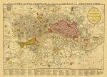
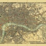
LONDON MAP 1814 – The Stranger’s Guide Through the Streets of London and Westminster & c. A new and Correct Plan of London and Westminster with the Latest Improvements. Extending north to south from Somers Town to Walworth and East to West from Ratcliff to Knightsbridge. With a 200 point key underneath listing principal streets.
| Weight | N/A |
|---|---|
| Size | 51×37 cm, 84×60 cm |


No account yet?
Create an Account


1 review for THE STRANGER’S GUIDE THROUGH THE STREETS OF LONDON AND WESTMINSTER, YEAR 1814
Clear filters