


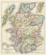


SCOTLAND 1847
Price range: £29.00 through £49.00
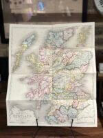
Old Map reprint of Scotland
* Linen Backed by Hand.
* Folding Map. Fitted into a marbled slipcase.
8 People watching this product now!
Description
✶✶✶ Unique Old Map Reproduction ✶✶✶
BETT’s new map of Scotland Embracing All the Principal Objects of Interests to the Tourist, And Shewing The Various Lines Of Railroad, The Turnpike, And Principal Cross Roads, Lakes, Rivers &c &c.
YEAR: 1847
CARTOGRAPHER: John Betts
Additional information
| Weight | N/A |
|---|---|
| Size | 40×48 cm ,60×72 cm |
Shipping & Delivery
Product Information

Our unique product have been meticulously crafted, with great care and attention to detail.
✶ All Maps and illustrations are linen-backed by hand.
✶ Printed on Archival Matte Paper.
✶ Quality Epson pigment inks used. Fade resistant.
✶ Maps are folded and fitted into a hand wrapped marbled slipcase.
✶ Illustrations are rolled and posted in a sturdy cardboard tube.
✶ Dimensions are approximately. Select size from the menu.
✶ Colours may vary due to monitor resolution.

Related products
41x49 cm
59x72cm


Reviews
Clear filtersThere are no reviews yet.