Wishlist
Search
  • Home
  • Shop
    • London Maps
    • Continents & World
    • Country Maps
    • City Maps
    • UK Cities & Counties
    • Antique Illustrations
  • Inspirations
  • Blog
  • About Us
  • Contact us
Login / Register
0 items £0.00
Menu
0 items £0.00
Click to enlarge
Home City Maps NEW YORK 1847
EDINBURGH 1834 £27.00 – £45.00
Back to products
PARIS 1878 £27.00 – £45.00

NEW YORK 1847

£27.00 – £45.00

Clear
Buy with

– OR –

Add to wishlist
11 People watching this product now!
SKU: N/A Category: City Maps Tags: 1847, city, handmade, linen backed, maps, new, york
Share:
Close
YOU MAY ALSO LIKE…
  • RUSSIA 1864 £27.00 – £45.00
  • PARIS 1852 £45.00 – £90.00
  • JAMAICA 1851 £27.00
  • ANIMALS (Mamiferes) Circa 1897 £23.00
  • OXFORDSHIRE 1750 £27.00
  • WARWICKSHIRE 1787 £27.00
  • Description
  • Additional information
  • Reviews (0)
  • Shipping & Delivery
  • Product Information
Description

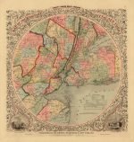
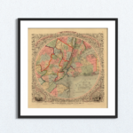
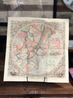
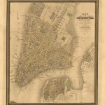
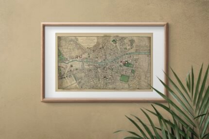
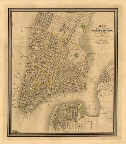
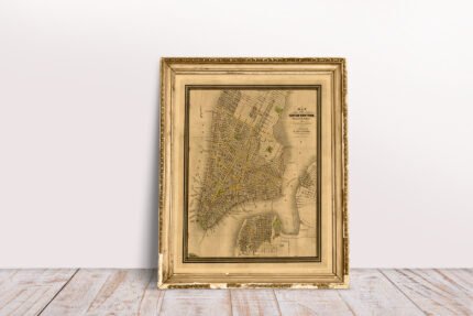
MAP OF THE COUNTRY THIRTY-THREE MILES AROUND THE CITY OF NEW YORK.

A fine reproduction of one of the most beautiful pocket maps of New York made in the 19th century: Colton’s Thirty-Three Miles Around the City of New York. Covers New York City and vicinity as far south as Ocean County, New Jersey, as far east as Suffolk County, as far north as Rockland County, and as far west as Somerset County. Surrounded by a splendid decorative border with engraved views depicting “City Hall, New York” and “City Hall, Brooklyn”.  Published by J.H Colton and Drawn by G.W.Colton.

YEAR: 1847
CARTOGRAPHER: J.H Colton

Additional information
Weight N/A
Size

48×45 cm, 63×60 cm

Reviews (0)
Rated 0 out of 5
0 reviews
Rated 5 out of 5
0
Rated 4 out of 5
0
Rated 3 out of 5
0
Rated 2 out of 5
0
Rated 1 out of 5
0

Reviews

Clear filters

There are no reviews yet.

Be the first to review “NEW YORK 1847” Cancel reply

You must be logged in to post a review.

Shipping & Delivery

All Orders are processed within by next day - Monday through Friday (excluding holidays). Orders are not shipped or delivered on weekends or holidays.

If We are experiencing a high volume of orders, shipments may be delayed by a few days. Please allow additional days in transit for delivery. If there will be a significant delay in shipment of Your Order, We will contact You via email.

Shipping rates & delivery estimates

Shipping charges for Your Orders will be calculated and displayed at checkout.

UK Delivery:

●  Shipping method: Royal Mail 2nd Class Standard

●  Shipment cost: Free

Estimated delivery time: 3-5 business days


Worldwide Delivery:

●  Shipping method: Royal Mail International Tracked & Signed

●  Shipping cost: Calculated at checkout according to weight, size and Zones. (View Table)

●  Estimated delivery time: 8-14 business days

Delivery delays can occasionally occur.

Europe

Zone 1

Zone 2

Zone 3

Small Map Size

£9.90

£11.20

£12.25

£11.35

Large Map Size

£14.20

£20.35

£22.10

£23.75

Illustrations (tube)

£12.65

£16.45

£17.60

£18.35

World Zone 1: Covers all countries, not defined as being in Europe or World Zone 2. (World Zone 1 generally covers countries in North America, South America, the Middle East, the Far East and South East Asia).

World Zone 2: Australia, Belau(Palau), China (including Tibet), East Timor, Fiji, French Southern and Antarctic Territories, French Polynesia, Guam, Japan, Kiribati, Korea, Marshall Islands, Micronesia, Mongolia, Nauru Islands, New Caledonia, New Zealand, Norfolk Island, North Marina Island, Papua New Guinea, Philippines, Pitcairn Island, Samoa, Solomon Islands, Singapore, Taiwan, Tonga, Tuvalu, Vanuatu, Wake Island, Wallis and Futuna Islands, Western Samoa.

World Zone 3: USA


* Prices may vary according to size and weight. Final shipping fees are calculated at checkout.

Product Information

Our unique product have been meticulously crafted, with great care and attention to detail.

✶ All Maps and illustrations are linen-backed by hand.
✶ Printed on Archival Matte Paper.
✶ Quality Epson pigment inks used. Fade resistant.
✶ Maps are folded and fitted into a hand wrapped marbled slipcase.
✶ Illustrations are rolled and posted in a sturdy cardboard tube.
✶ Dimensions are approximately. Select size from the menu.
✶ Colours may vary due to monitor resolution.

Linen backing provided several benefits to cartographers and map enthusiasts:

✶ Preservation: The technique helps protect paper maps from further deterioration by providing a stronger and more stable support.
✶ Sturdiness: Linen backing make maps more durable, preventing tearing and creasing during handling and storage.
✶ Display: Backed maps are easier to frame and display due to their enhanced stability and ability to lie flat.

Related products

Select options
Quick view
Add to wishlist
41x49 cm

ARGENTINE REPUBLIC, CHILI, URUGUAY, PARAGUAY 1856

Country Maps
£27.00
Sold out
Select options
Quick view
Add to wishlist
88x60 cm

ROME 1829

City Maps
£45.00
Select options
Quick view
Add to wishlist
51x36 cm
80x60 cm

CENTRAL LONDON, NORTH WEST 1901

London Maps
£27.00 – £45.00
Select options
Quick view
Add to wishlist
126x83 cm
90x58 cm

CARY’S NEW AND ACCURATE PLAN OF LONDON 1795

London Maps
£45.00 – £90.00
Select options
Quick view
Add to wishlist
52x40 cm

CUBA 1862

Country Maps
£27.00
Select options
Quick view
Add to wishlist
51x34 cm

FIRE OF LONDON – A PLAN OF THE CITY AND LIBERTIES OF LONDON 1666

London Maps
£27.00
Select options
Quick view
Add to wishlist
37x52 cm
60x86 cm

BRAZIL 1851

Country Maps
£27.00 – £45.00
Select options
Quick view
Add to wishlist
124x90 cm
51x37 cm
84x60 cm

THE STRANGER’S GUIDE THROUGH THE STREETS OF LONDON AND WESTMINSTER, YEAR 1814

London Maps
£27.00 – £90.00
You must select your brand attribute in Theme Settings -> Shop -> Brands
  • +44 753 4988 166
  • info@oldmapslibrary.com
Recent Posts
  • Woman in Cartography
    22/03/2023 No Comments
  • Vintage Maps and Home Deco – The beauty lies in the contrast
    28/02/2023 No Comments
CATEGORIES
  • London Maps
  • Continents & World
  • Country Maps
  • City Maps
  • UK Cities & Counties
  • Antique Illustrations
LEGAL
  • Terms & Conditions
  • Privacy Policy
  • FAQ
  • Delivery
  • Returns
Get In Touch
  • Contact us
  • About Us
  • Facebook
  • Instagram
  • Pinterest
Copyright © 2023, OLD MAPS LIMITED. All Rights Reserved.
payments
  • Menu
  • Categories
  • London Maps
  • Continents & World
  • Country Maps
  • City Maps
  • UK Cities & Counties
  • Antique Illustrations
  • Home
  • Shop
  • Blog
  • About Us
  • Contact us
  • Wishlist
  • Login / Register
Shopping cart
Close
  • Free UK Shipping
  • Worldwide Shipping
  • Unique Product
  • Satisfied Customers
Sign in
Close

Lost your password?

No account yet?

Create an Account
Start typing to see products you are looking for.
Shop
Sidebar
Wishlist
0 items Cart
My account