- Free UK Shipping
- Worldwide Shipping
- Unique Product
- Satisfied Customers
Price range: £29.00 through £49.00
✶✶✶ Unique Handmade Old Map Reproduction ✶✶✶
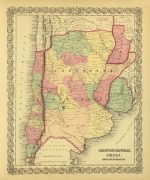
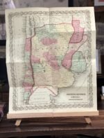
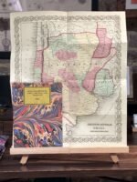
This is a fine map of Argentina, Chile, Paraguay, and Uruguay.
The Map covers from Bolivia to Patagonia and from the Pacific to the Atlantic, and also identifies various cities, towns, forts, rivers, rapids, mountain passes, fords, and additional topographical details.
| Weight | N/A |
|---|---|
| Dimensions | N/A |
| Size | 41×49 cm, 59x72cm |


No account yet?
Create an Account


Reviews
Clear filtersThere are no reviews yet.