


CUBA 1862
£29.00
Old Map reprint of Cuba, Jamaica, the Bahamas, and Porto Rico
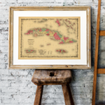
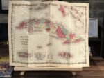
* Linen Backed by Hand.
* Folding Map. Fitted into a marbled slipcase.
8 People watching this product now!
Description
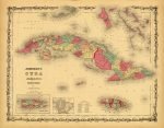
✶✶✶ Unique Old Map Reproduction ✶✶✶
A beautiful map of Cuba, Jamaica, the Bahamas, and Porto Rico.
This map also shows part of the Florida Keys. Offers superb detail of the entire region, including roadways, cities, provinces, and undersea dangers. Two insets in the lower left detail Porto Rico and the City and Harbour of Havana, Cuba. Features the strapwork style border common to Johnson’s Atlas work from 1860 to 1863, and it was part of the 1862 edition of Johnson’s New Illustrated Family Atlas.
CARTOGRAPHER: A.J. JOHNSON
YEAR: 1862
Additional information
| Weight | N/A |
|---|---|
| Size | 52×40 cm |
Shipping & Delivery
Product Information

Our unique product have been meticulously crafted, with great care and attention to detail.
✶ All Maps and illustrations are linen-backed by hand.
✶ Printed on Archival Matte Paper.
✶ Quality Epson pigment inks used. Fade resistant.
✶ Maps are folded and fitted into a hand wrapped marbled slipcase.
✶ Illustrations are rolled and posted in a sturdy cardboard tube.
✶ Dimensions are approximately. Select size from the menu.
✶ Colours may vary due to monitor resolution.


Reviews
Clear filtersThere are no reviews yet.