- Free UK Shipping
- Worldwide Shipping
- Unique Product
- Satisfied Customers
£29.00
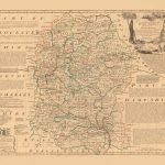
A great map of the County of WORCESTER Divided into its Hundreds and drawn from the best Authorities. Illustrated with Historical Extracts relative to Natural History, produce Trade & Manufactures. Showing also amongst various improvements, the Rectories, Vicarages, Charity Schools, Religious Houses & c.
| Weight | N/A |
|---|---|
| Size | 51×40 cm |


No account yet?
Create an Account


Reviews
Clear filtersThere are no reviews yet.