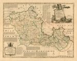
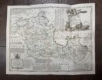
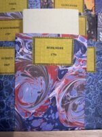
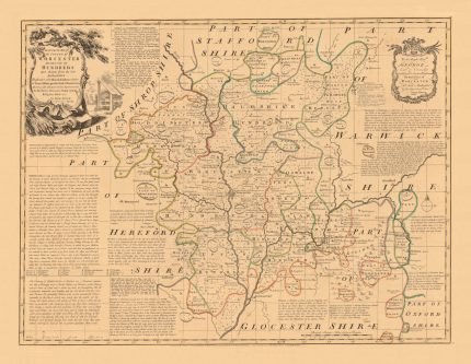
Wishlist
Search
  • Home
  • Shop
    • London Maps
    • Continents & World
    • Country Maps
    • City Maps
    • UK Cities & Counties
    • Antique Illustrations
  • Inspirations
  • Blog
  • About Us
  • Contact us
Login / Register
0 items £0.00
Menu
0 items £0.00
Click to enlarge
Home UK Cities & Counties BERKSHIRE 1756
THE SHIRES OF ROSS AND CROMARTIE 1725 £27.00
Back to products
BIRMINGHAM 1851 £27.00

BERKSHIRE 1756

£27.00

Clear
Buy with

– OR –

Add to wishlist
9 People watching this product now!
SKU: N/A Category: UK Cities & Counties Tags: &, 1756, berkshire, cities, counties, handmade, linen backed, uk
Share:
Close
YOU MAY ALSO LIKE…
  • ARABIA 1851 £27.00 – £45.00
  • NEWCASTLE 1851 £27.00
  • CUBA 1862 £27.00
  • JAPAN 1864 £27.00 – £45.00
  • THE SHIRE OF ANGUS OR FORFAR 1725 £27.00
  • SHEFFIELD 1851 £27.00
  • Description
  • Additional information
  • Reviews (0)
  • Shipping & Delivery
  • Product Information
Description

A fine reproduction of an accurate map of Berkshire divided into its hundreds. Drawn from the best authorities assisted by Surveys and most approved maps with various improvements. Illustrated with historical extracts relative to Trade, Manufactures, Natural Produce, & present State of the principal Towns &c. By Eman: Bowen Geographer to His Majesty.
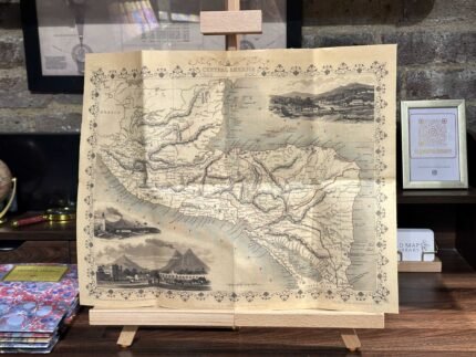
Copper engraving by Emanuel Bowen published in The Large English Atlas from 1760. The work was the first large scale atlas of English counties since the works of Blaeu and Jansson a century earlier and was based on the latest surveys available. The maps were a long time in preparation, the engraving work mostly shared between Emanuel Bowen and Thomas Kitchen, beginning in 1749 with the county of Sussex and reaching completion of 45 plates in 1760. During this time the plates passed through the hands of several publishers and were issued individually and in part works without a title.

CARTOGRAPHER: Emanuel Bowen

YEAR: 1756

Additional information
Weight N/A
Size

51×40 cm

Reviews (0)
Rated 0 out of 5
0 reviews
Rated 5 out of 5
0
Rated 4 out of 5
0
Rated 3 out of 5
0
Rated 2 out of 5
0
Rated 1 out of 5
0

Reviews

Clear filters

There are no reviews yet.

Be the first to review “BERKSHIRE 1756” Cancel reply

You must be logged in to post a review.

Shipping & Delivery

All Orders are processed within by next day - Monday through Friday (excluding holidays). Orders are not shipped or delivered on weekends or holidays.

If We are experiencing a high volume of orders, shipments may be delayed by a few days. Please allow additional days in transit for delivery. If there will be a significant delay in shipment of Your Order, We will contact You via email.

Shipping rates & delivery estimates

Shipping charges for Your Orders will be calculated and displayed at checkout.

UK Delivery:

●  Shipping method: Royal Mail 2nd Class Standard

●  Shipment cost: Free

Estimated delivery time: 3-5 business days


Worldwide Delivery:

●  Shipping method: Royal Mail International Tracked & Signed

●  Shipping cost: Calculated at checkout according to weight, size and Zones. (View Table)

●  Estimated delivery time: 8-14 business days

Delivery delays can occasionally occur.

Europe

Zone 1

Zone 2

Zone 3

Small Map Size

£9.90

£11.20

£12.25

£11.35

Large Map Size

£14.20

£20.35

£22.10

£23.75

Illustrations (tube)

£12.65

£16.45

£17.60

£18.35

World Zone 1: Covers all countries, not defined as being in Europe or World Zone 2. (World Zone 1 generally covers countries in North America, South America, the Middle East, the Far East and South East Asia).

World Zone 2: Australia, Belau(Palau), China (including Tibet), East Timor, Fiji, French Southern and Antarctic Territories, French Polynesia, Guam, Japan, Kiribati, Korea, Marshall Islands, Micronesia, Mongolia, Nauru Islands, New Caledonia, New Zealand, Norfolk Island, North Marina Island, Papua New Guinea, Philippines, Pitcairn Island, Samoa, Solomon Islands, Singapore, Taiwan, Tonga, Tuvalu, Vanuatu, Wake Island, Wallis and Futuna Islands, Western Samoa.

World Zone 3: USA


* Prices may vary according to size and weight. Final shipping fees are calculated at checkout.

Product Information

Our unique product have been meticulously crafted, with great care and attention to detail.

✶ All Maps and illustrations are linen-backed by hand.
✶ Printed on Archival Matte Paper.
✶ Quality Epson pigment inks used. Fade resistant.
✶ Maps are folded and fitted into a hand wrapped marbled slipcase.
✶ Illustrations are rolled and posted in a sturdy cardboard tube.
✶ Dimensions are approximately. Select size from the menu.
✶ Colours may vary due to monitor resolution.

Linen backing provided several benefits to cartographers and map enthusiasts:

✶ Preservation: The technique helps protect paper maps from further deterioration by providing a stronger and more stable support.
✶ Sturdiness: Linen backing make maps more durable, preventing tearing and creasing during handling and storage.
✶ Display: Backed maps are easier to frame and display due to their enhanced stability and ability to lie flat.

Related products

Select options
Quick view
Add to wishlist

AFRICA 1851

Continents & World
£27.00 – £45.00
Select options
Quick view
Add to wishlist
52x41 cm
78x61 cm

ASIA 1851

Continents & World
£27.00 – £45.00
Select options
Quick view
Add to wishlist
89x60 cm

OTTOMAN EMPIRE 1853

Continents & World
£45.00
Select options
Quick view
Add to wishlist
40x48 cm
60x82 cm

SOUTH AMERICA 1856

Continents & World
£27.00 – £45.00
Select options
Quick view
Add to wishlist
39x51 cm

FLOWERS Circa 1906

Antique Illustrations
£23.00
Select options
Quick view
Add to wishlist
51x39 cm

NORTH AFRICA 1851

Continents & World
£27.00
Select options
Quick view
Add to wishlist
49x40 cm
73x60 cm

BRITISH EMPIRE 1872

Continents & World
£27.00 – £45.00
Select options
Quick view
Add to wishlist
60x61 cm
90x90 cm

TWENTY MILES ROUND LONDON 1800

London Maps
£45.00 – £90.00
You must select your brand attribute in Theme Settings -> Shop -> Brands
  • +44 753 4988 166
  • info@oldmapslibrary.com
Recent Posts
  • Woman in Cartography
    22/03/2023 No Comments
  • Vintage Maps and Home Deco – The beauty lies in the contrast
    28/02/2023 No Comments
CATEGORIES
  • London Maps
  • Continents & World
  • Country Maps
  • City Maps
  • UK Cities & Counties
  • Antique Illustrations
LEGAL
  • Terms & Conditions
  • Privacy Policy
  • FAQ
  • Delivery
  • Returns
Get In Touch
  • Contact us
  • About Us
  • Facebook
  • Instagram
  • Pinterest
Copyright © 2023, OLD MAPS LIMITED. All Rights Reserved.
payments
  • Menu
  • Categories
  • London Maps
  • Continents & World
  • Country Maps
  • City Maps
  • UK Cities & Counties
  • Antique Illustrations
  • Home
  • Shop
  • Blog
  • About Us
  • Contact us
  • Wishlist
  • Login / Register
Shopping cart
Close
  • Free UK Shipping
  • Worldwide Shipping
  • Unique Product
  • Satisfied Customers
Sign in
Close

Lost your password?

No account yet?

Create an Account
Start typing to see products you are looking for.
Shop
Sidebar
Wishlist
0 items Cart
My account