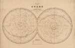
Wishlist
Search
  • Home
  • Shop
    • London Maps
    • Continents & World
    • Country Maps
    • City Maps
    • UK Cities & Counties
    • Antique Illustrations
  • Inspirations
  • Blog
  • About Us
  • Contact us
Login / Register
0 items £0.00
Menu
0 items £0.00
Click to enlarge
Home Antique Illustrations THE STARS 1841
LEICESTER SHIRE 1787 £27.00
Back to products
BRIGHTON 1851 £27.00

THE STARS 1841

£23.00

Clear
Buy with

– OR –

Add to wishlist
15 People watching this product now!
SKU: N/A Category: Antique Illustrations Tags: Antique Illustrations, THE STARS 1841
Share:
Close
YOU MAY ALSO LIKE…
  • SCOTLAND 1851 £27.00 – £45.00
  • DUBLIN 1787 £27.00 – £45.00
  • LEICESTER AND RUTLAND 1760 £27.00
  • LINCOLNSHIRE, 1801 £27.00
  • ISTANBUL 1752 £27.00
  • IRELAND 1798 £27.00 – £45.00
  • Description
  • Additional information
  • Reviews (0)
  • Shipping & Delivery
  • Product Information
Description

A reprint map of The Stars, Northern and Southern Hemisphere.

The constellations shown are those defined in the first quarter of the nineteenth century, including some of those now no longer used.

They are defined by their name in Latin and recognisable by a hatch that unites not the brightest stars but the perimeter ones. No mention of the drawing of the mythological characters.


YEAR: 1841

CARTOGRAPHER: JAMES WYLD

Additional information
Weight N/A
Size

51×33 cm

Reviews (0)
Rated 0 out of 5
0 reviews
Rated 5 out of 5
0
Rated 4 out of 5
0
Rated 3 out of 5
0
Rated 2 out of 5
0
Rated 1 out of 5
0

Reviews

Clear filters

There are no reviews yet.

Be the first to review “THE STARS 1841” Cancel reply

You must be logged in to post a review.

Shipping & Delivery

All Orders are processed within by next day - Monday through Friday (excluding holidays). Orders are not shipped or delivered on weekends or holidays.

If We are experiencing a high volume of orders, shipments may be delayed by a few days. Please allow additional days in transit for delivery. If there will be a significant delay in shipment of Your Order, We will contact You via email.

Shipping rates & delivery estimates

Shipping charges for Your Orders will be calculated and displayed at checkout.

UK Delivery:

●  Shipping method: Royal Mail 2nd Class Standard

●  Shipment cost: Free

Estimated delivery time: 3-5 business days


Worldwide Delivery:

●  Shipping method: Royal Mail International Tracked & Signed

●  Shipping cost: Calculated at checkout according to weight, size and Zones. (View Table)

●  Estimated delivery time: 8-14 business days

Delivery delays can occasionally occur.

Europe

Zone 1

Zone 2

Zone 3

Small Map Size

£9.90

£11.20

£12.25

£11.35

Large Map Size

£14.20

£20.35

£22.10

£23.75

Illustrations (tube)

£12.65

£16.45

£17.60

£18.35

World Zone 1: Covers all countries, not defined as being in Europe or World Zone 2. (World Zone 1 generally covers countries in North America, South America, the Middle East, the Far East and South East Asia).

World Zone 2: Australia, Belau(Palau), China (including Tibet), East Timor, Fiji, French Southern and Antarctic Territories, French Polynesia, Guam, Japan, Kiribati, Korea, Marshall Islands, Micronesia, Mongolia, Nauru Islands, New Caledonia, New Zealand, Norfolk Island, North Marina Island, Papua New Guinea, Philippines, Pitcairn Island, Samoa, Solomon Islands, Singapore, Taiwan, Tonga, Tuvalu, Vanuatu, Wake Island, Wallis and Futuna Islands, Western Samoa.

World Zone 3: USA


* Prices may vary according to size and weight. Final shipping fees are calculated at checkout.

Product Information

Our unique product have been meticulously crafted, with great care and attention to detail.

✶ All Maps and illustrations are linen-backed by hand.
✶ Printed on Archival Matte Paper.
✶ Quality Epson pigment inks used. Fade resistant.
✶ Maps are folded and fitted into a hand wrapped marbled slipcase.
✶ Illustrations are rolled and posted in a sturdy cardboard tube.
✶ Dimensions are approximately. Select size from the menu.
✶ Colours may vary due to monitor resolution.

Linen backing provided several benefits to cartographers and map enthusiasts:

✶ Preservation: The technique helps protect paper maps from further deterioration by providing a stronger and more stable support.
✶ Sturdiness: Linen backing make maps more durable, preventing tearing and creasing during handling and storage.
✶ Display: Backed maps are easier to frame and display due to their enhanced stability and ability to lie flat.

Related products

Select options
Quick view
Add to wishlist
51x38 cm

THE UNIVERSE 1841

Antique Illustrations
£23.00
Select options
Quick view
Add to wishlist
37x51 cm

SIPHONOPHORAE Circa 1904

Antique Illustrations
£23.00
Select options
Quick view
Add to wishlist
37x51 cm

OCTOPUS (Gamochonia) circa 1899

Antique Illustrations
£23.00
Select options
Quick view
Add to wishlist
33x51 cm

ANIMALS (Mamiferes) Circa 1897

Antique Illustrations
£23.00
Select options
Quick view
Add to wishlist
34x51 cm

BUTTERFLIES (Papillons) Circa 1897

Antique Illustrations
£23.00
Select options
Quick view
Add to wishlist
35x51 cm

OCEANOGRAPHY (Oceanographie) Circa 1897

Antique Illustrations
£23.00
Select options
Quick view
Add to wishlist
39x51 cm

THE MOON (La Lune) 1887

Antique Illustrations
£23.00
Select options
Quick view
Add to wishlist
40x45 cm

THE NIGHT SKY STAR MAP

Antique Illustrations
£23.00
You must select your brand attribute in Theme Settings -> Shop -> Brands
  • +44 753 4988 166
  • info@oldmapslibrary.com
Recent Posts
  • Woman in Cartography
    22/03/2023 No Comments
  • Vintage Maps and Home Deco – The beauty lies in the contrast
    28/02/2023 No Comments
CATEGORIES
  • London Maps
  • Continents & World
  • Country Maps
  • City Maps
  • UK Cities & Counties
  • Antique Illustrations
LEGAL
  • Terms & Conditions
  • Privacy Policy
  • FAQ
  • Delivery
  • Returns
Get In Touch
  • Contact us
  • About Us
  • Facebook
  • Instagram
  • Pinterest
Copyright © 2023, OLD MAPS LIMITED. All Rights Reserved.
payments
  • Menu
  • Categories
  • London Maps
  • Continents & World
  • Country Maps
  • City Maps
  • UK Cities & Counties
  • Antique Illustrations
  • Home
  • Shop
  • Blog
  • About Us
  • Contact us
  • Wishlist
  • Login / Register
Shopping cart
Close
  • Free UK Shipping
  • Worldwide Shipping
  • Unique Product
  • Satisfied Customers
Sign in
Close

Lost your password?

No account yet?

Create an Account
Start typing to see products you are looking for.
Shop
Sidebar
Wishlist
0 items Cart
My account