- Free UK Shipping
- Worldwide Shipping
- Unique Product
- Satisfied Customers
Price range: £29.00 through £49.00
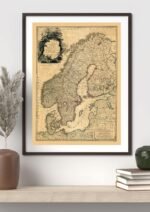
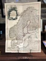
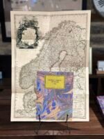
Map of a Scandia or Scandinavia comprehending Sweden, and Norway, with the Danish Islands; to which is added the remainder of the possessions of Denmark. Map of Scandinavia by Louis Stanislas d’Arcy de la Rochette, which appeared in Faden’s General Atlas. His early addition pre-dates the Napoleonic Wars and shows Norway and Denmark as unified, and Finland as part of Sweden. The map reflects the art of map printing at one of its high points, employing high-quality handmade paper, fine copperplate engraving, and rich elegant hand colouring. The detail throughout the map is remarkable and is embellished with a decorative cartouche. The map shows towns, duchy, rivers, lakes, roads, bays, islands, and other important details.
| Weight | N/A |
|---|---|
| Size | 37×51 cm, 60×84 cm |


No account yet?
Create an Account


Reviews
Clear filtersThere are no reviews yet.