


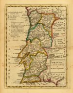

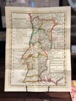

PORTUGAL 1736
Price range: £29.00 through £49.00
Old Map reprint of Portugal.
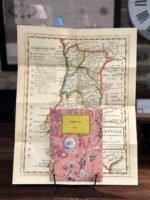
* Linen Backed by Hand.
* Folding Map. Fitted into a marbled slipcase.
8 People watching this product now!
Description
✶✶✶ Unique Old Map Reproduction ✶✶✶
Map of Portugal, agreeable to modern history by Herman Moll, Geographer.
CARTOGRAPHER: Herman Moll.
YEAR: 1736
Herman Moll (c. 1654-1732) was one of the most important London mapmakers in the first half of the eighteenth century. Moll was probably born in Bremen, Germany, around 1654. He moved to London to escape the Scanian Wars. His earliest work was as an engraver for Moses Pitt on the production of the English Atlas, a failed work which, landed Pitt in debtor’s prison. Moll also engraved for Sir Jonas Moore, Grenville Collins, John Adair, and the Seller & Price firm. He published his first original maps in the early 1680s, and had set up his own shop by the 1690s.
Moll’s work quickly helped him become a member of a group which, congregated at Jonathan’s Coffee House at Number 20 Exchange Alley, Cornhill, where speculators met to trade stock. Moll’s circle included the scientist Robert Hooke, the archaeologist William Stuckley, the authors Jonathan Swift and Daniel Defoe, and the intellectually-gifted pirates William Dampier, Woodes Rogers and William Hacke. From these contacts, Moll gained a great deal of privileged information that was included in his maps.
Over the course of his career, he published dozens of geographies, atlases, and histories, not to mention numerous sheet maps. His most famous works are Atlas Geographus, a monthly magazine that ran from 1708 to 1717, and The World Described (1715-54). He also frequently made maps for books, including those of Dampier’s publications and Swift’s Gulliver’s Travels. Moll died in 1732. It is likely that his plates passed to another contemporary, Thomas Bowles, after this death.
Additional information
| Weight | N/A |
|---|---|
| Dimensions | N/A |
| Size | 40×51 cm ,58x75cm |
Shipping & Delivery
Product Information

Our unique product have been meticulously crafted, with great care and attention to detail.
✶ All Maps and illustrations are linen-backed by hand.
✶ Printed on Archival Matte Paper.
✶ Quality Epson pigment inks used. Fade resistant.
✶ Maps are folded and fitted into a hand wrapped marbled slipcase.
✶ Illustrations are rolled and posted in a sturdy cardboard tube.
✶ Dimensions are approximately. Select size from the menu.
✶ Colours may vary due to monitor resolution.


Reviews
Clear filtersThere are no reviews yet.