- Free UK Shipping
- Worldwide Shipping
- Unique Product
- Satisfied Customers


£29.00
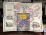
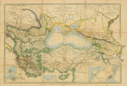
Map of Johnson’s Turkey in Asia, Persia, Arabia & c. by Johnson and Ward. A great example of A. J. Johnson’s 1866 map of Arabia, Persia, and Turkey in Asia. Covers from the Mediterranean and Egypt eastwards as far as the Mouths of the Indus River, as well as southward. As far as the Horn of Africa and northwards to the Black Sea. Depicts most of the politically volatile modern-day Middle East, including the nations of Afghanistan, Iraq, Iran, Saudi Arabia, Jordan, Israel, Syria, Lebanon, and Turkey. Offers colour coding according to country and region, as well as notations regarding desert caravan routes, oases, roadways, river systems, forts and monasteries, and some topographical features.
| Weight | N/A |
|---|---|
| Size | 51×38 cm |


No account yet?
Create an Account


1 review for MIDDLE EAST 1866
Clear filtersThere are no reviews yet.