- Free UK Shipping
- Worldwide Shipping
- Unique Product
- Satisfied Customers
Price range: £28.00 through £48.00
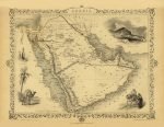
Map of ARABIA. A fine decorative and detailed mid 19th century map of the Arabian peninsula, drawn and engraved by J. Rapkin (vignettes by H. Warren & J. Rogers) and published in John Tallis’s Illustrated Atlas (London & New York: John Tallis & Co, c.1851). Illustrated are views of Mount Sinai, a dromedary camel, and Arab men and women.
| Weight | N/A |
|---|---|
| Size | 52×40 cm, 79×60 cm |

No account yet?
Create an Account













%20Circa%201897&url=https://www.oldmapslibrary.com/product/mushrooms-champignons-circa-1897/&media=https://www.oldmapslibrary.com/wp-content/uploads/2023/07/Adolphe_Millot_champignons-pour_tous-536x800.jpg)


1 review for ARABIA 1851
Clear filters