- Free UK Shipping
- Worldwide Shipping
- Unique Product
- Satisfied Customers
£29.00
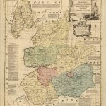
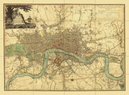
An accurate map of County of Kent. Divided into its Lathes, and subdivided into Hundreds. Drawn from surveys, and most approved modern maps, with various additional improvements: Illustrated with Historical Extracts relative to the Air, Soil, Natural Produce, Manufacture, trade and present state of its Cities & principal towns. By Eman: Bowen Geographer to His Majesty. History: This map was usually published in the “Large English Atlas” the best county atlas of the 18th century, with maps by Emanuel Bowen, Thomas Bowen and one, Middlesex, by R.W.Seale.
| Weight | N/A |
|---|---|
| Size | 51×39 cm |


No account yet?
Create an Account


%20Circa%201897&url=https://www.oldmapslibrary.com/product/mushrooms-champignons-circa-1897/&media=https://www.oldmapslibrary.com/wp-content/uploads/2023/07/Adolphe_Millot_champignons-pour_tous-536x800.jpg)
1 review for KENT 1740
Clear filters