- Free UK Shipping
- Worldwide Shipping
- Unique Product
- Satisfied Customers
£29.00 – £49.00Price range: £29.00 through £49.00
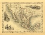
Map of MEXICO / CALIFORNIA / TEXAS. This map was drawn at the height of the California Gold Rush and responds to the international interest in the region by highlighting the goldfields in the Sacramento and San Joaquin valley. The “Great Caravan Route” used by covered wagons during the westward expansion is also noted. It also offers several beautiful vignettes drawn by H. Warren and J. Rogers, showing the Ruins at Uxmal, Yucatan, panning gold in California and Mexican Peasantry. Drawn by John Rapkin for issue in the 1851 edition of John Tallis’ Illustrated Atlas
| Weight | N/A |
|---|---|
| Size | 51×40 cm, 76×60 cm |
Europe | Zone 1 | Zone 2 | Zone 3 | |
|---|---|---|---|---|
Small Map Size | £9.90 | £11.20 | £12.25 | £11.35 |
Large Map Size | £14.20 | £20.35 | £22.10 | £23.75 |
Illustrations (tube) | £12.65 | £16.45 | £17.60 | £18.35 |
World Zone 1: Covers all countries, not defined as being in Europe or World Zone 2. (World Zone 1 generally covers countries in North America, South America, the Middle East, the Far East and South East Asia).
World Zone 2: Australia, Belau(Palau), China (including Tibet), East Timor, Fiji, French Southern and Antarctic Territories, French Polynesia, Guam, Japan, Kiribati, Korea, Marshall Islands, Micronesia, Mongolia, Nauru Islands, New Caledonia, New Zealand, Norfolk Island, North Marina Island, Papua New Guinea, Philippines, Pitcairn Island, Samoa, Solomon Islands, Singapore, Taiwan, Tonga, Tuvalu, Vanuatu, Wake Island, Wallis and Futuna Islands, Western Samoa.
World Zone 3: USA


No account yet?
Create an Account
Reviews
Clear filtersThere are no reviews yet.