- Free UK Shipping
- Worldwide Shipping
- Unique Product
- Satisfied Customers
£49.00
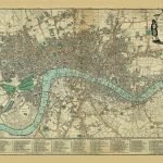
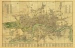
Cary’s New Accurate Plan of London and Westminster the Borough of Southwark and parts adjacent: viz.Kensington, Chelsea, Islington, Hackney, Walworth, Newington, etc with an Alphabetical list of upwards of 500 of the most principal streets with references to their situation.
CARTOGRAPHER: John Cary
| Weight | N/A |
|---|---|
| Size | 90×58 cm |
Europe | Zone 1 | Zone 2 | Zone 3 | |
|---|---|---|---|---|
Small Map Size | £9.90 | £11.20 | £12.25 | £11.35 |
Large Map Size | £14.20 | £20.35 | £22.10 | £23.75 |
Illustrations (tube) | £12.65 | £16.45 | £17.60 | £18.35 |
World Zone 1: Covers all countries, not defined as being in Europe or World Zone 2. (World Zone 1 generally covers countries in North America, South America, the Middle East, the Far East and South East Asia).
World Zone 2: Australia, Belau(Palau), China (including Tibet), East Timor, Fiji, French Southern and Antarctic Territories, French Polynesia, Guam, Japan, Kiribati, Korea, Marshall Islands, Micronesia, Mongolia, Nauru Islands, New Caledonia, New Zealand, Norfolk Island, North Marina Island, Papua New Guinea, Philippines, Pitcairn Island, Samoa, Solomon Islands, Singapore, Taiwan, Tonga, Tuvalu, Vanuatu, Wake Island, Wallis and Futuna Islands, Western Samoa.
World Zone 3: USA


No account yet?
Create an Account
1 review for CARY’S NEW AND ACCURATE PLAN OF LONDON 1795
Clear filtersThere are no reviews yet.